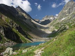
Hohe Tauern National Park is the largest national park in Austria and the biggest protected area in the Alps — a colossal 1,856 km² wilderness spanning the states of Salzburg, Carinthia, and Tyrol that encompasses Austria’s highest peak (Grossglockner, 3,798m), over 300 mountains above 3,000 metres, 342 glaciers, and the spectacular Grossglockner High Alpine Road — one of the most dramatic driving experiences in Europe. At the heart of the park lies the Grossglockner massif, Austria’s most iconic mountain landscape, accessible to visitors via the 48-kilometre Grossglockner High Alpine Road — a breathtaking ribbon of 36 hairpin turns that climbs to 2,504 metres at the Edelweißspitze and delivers views that have drawn travellers to this corner of the Eastern Alps since its construction in 1935.
Quick Facts: Hohe Tauern National Park
- Best time to visit: June–September for hiking and the Grossglockner High Alpine Road (the road is open approximately May–October, depending on snow conditions); July–August for the best alpine flower displays; the park is a winter destination for ski touring and snowshoeing but the high road and many facilities are closed
- How to get there: The northern entrance (Fusch an der Großglocknerstraße) is ~1.5 hours from Salzburg; the southern entrance (Heiligenblut) is ~2 hours from Klagenfurt
- Grossglockner High Alpine Road toll: ~€40 per car (day pass) – expensive but worth it; multi-day passes available
- Wildlife: Ibex, chamois, golden eagle, bearded vulture (successfully reintroduced), marmots — the classic Alpine cast is all present here
The National Park Hohe Tauern was established in 1981 and is Austria’s first National Park. During the following decades the National Park developed into the largest nature reserve in Central Europe, with an area of over 1,834 km2. The National Park Hohe Tauern lands in the three provinces of Tyrol, Salzburg (biggest share) and Carinthia.
The National Park includes the Central Alps with the highest mountain ranges of Austria, including Mount Großglockner (3798 metres high) and Mount Großvenediger (3666 metres high). The “Großglockner Hochalpenstraße” is an alpine road to near the mountain top and offers spectacular scenery. On the way upwards (or downwards), several museums tell the story of its construction in the 1930ies (mostly to fight unemployment and support tourism), the ecology of the region and other aspects of the “Tauern” mountains.
The Großglockner Hochalpenstraße is Austria′s second most popular attraction after Schönbrunn Palace in Vienna. Beyond this busy part of the park, there are plenty of areas that offer excellent hiking opportunities. The Krimml Waterfalls are another famous sight in the Hohe Tauern.
View National Park Hohe Tauern – the biggest national park of Austria in a larger map
Have you driven the Grossglockner road or hiked in Austria’s highest national park? Share your Hohe Tauern experiences in the comments! 🏔️
Discover more Austria travel guides and European mountain adventures.
