Determining the exact geographical centre of Europe is a surprisingly complicated exercise. The answer depends entirely on which borders you choose, which islands you include, and which calculation method you apply. Several locations across the continent claim the title, each supported by different scientific or historical reasoning. Since the last major re-estimation in 1989, the official Geographic Centre of Europe has been recognised near the village of Purnuškės in Lithuania, 26 kilometres north of Vilnius. A monument marks the spot. But the debate is far from settled, and the competing claims reveal as much about European identity as they do about geography.
It is quite hard to determine where is the midpoint of Europe – it depends on the boundaries estimation of Europe that are changing from time to time. Several calculations exist and there are several suggested places as the midpoint of Europe.
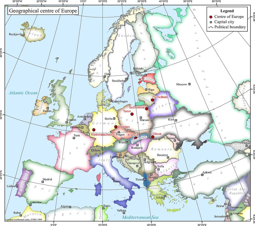
Since the last re-estimation in 1989, the official Geographic Centre of Europe is according to Jean-George Affholder, a scientist at the Institut Géographique National (French National Geographic Institute), in Lithuania, 26 kilometres north of the capital city, Vilnius, near the village of Purnuškės (Bernotai).
In This Article
The Competing Claims for the Centre of Europe
Beyond the officially recognised site in Lithuania, several other locations across Europe maintain their own claims to the title of continental midpoint. In western Ukraine, the small town of Rakhiv and the nearby village of Dilove both assert that they mark the geographical centre based on different calculation methods dating from the late 19th century. A stone monument erected by Austro-Hungarian surveyors in 1887 still stands in Dilove as evidence of this claim. Estonia enters the discussion with a point on the island of Saaremaa, which some calculations place at the centre when including all European islands up to the Ural Mountains. Central Slovakia puts forward the village of Krahule near Kremnica, while Poland offers both Suchowola northeast of Białystok and the city of Toruń as potential midpoints based on varying boundary definitions. Belarus stakes its claim with a location near Polotsk, and even Hungary has a memorial near Tállya that marks a calculated centre point. This proliferation of claims illustrates the fundamental challenge: Europe has no universally agreed eastern boundary, and different cartographers use different methods to define the continental limits.
The Shifting Centre of Europe
The geographical centre of Europe is an even more dynamic concept, shifting eastward with each wave of enlargement. When Europe had 12 member states, the centre lay in central France, near the village of Saint-André-le-Coq in the Puy-de-Dôme department of the Auvergne region. German reunification in 1990 pushed the centre about 25 kilometres northeast to Noireterre in the village of Saint-Clément, in the Allier department. A small monument there still commemorates this former midpoint. The expansion to 15 members in 1995 moved the centre to Viroinval in Belgium, where a monument records that calculation. With 25 members in 2004, the centre shifted to Kleinmaischeid in the Rhineland-Palatinate region of Germany. The most recent major shift came on 1 January 2007, when the inclusion of Romania and Bulgaria pushed the centre to a wheat field outside the German town of Gelnhausen in Hesse, 115 kilometres east of the previous marker. This ongoing eastward drift reflects Europe political project as much as any geographic calculation, with each new member state subtly altering the balance point of the union.
Visiting the European Midpoint Sites
For travellers interested in visiting these geographic curiosities, the Lithuanian site near Purnuškės is the most developed and accessible. Located about 26 kilometres north of Vilnius, the site features a monument designed by sculptor Gediminas Jokūbonis, consisting of white granite columns topped with a crown of stars. A paved path and informational plaques make it easy to reach by car or bicycle. The Ukrainian site near Rakhiv in the Carpathian Mountains offers a more rugged experience, set against the backdrop of the Carpathian landscape, though the political situation in the region has made access challenging in recent years. The Belgian site at Viroinval is well signposted and sits within the scenic Walloon countryside, making it an easy day trip from Brussels or Namur. Visitors to any of these sites should remember that the precise location matters less than what it represents: a continent constantly redefining its own boundaries and identity.
Which midpoint of Europe would you most want to visit and photograph? 🌍
Explore all our Europe travel guides, discover the best of the continent.
Explore More
If you enjoyed this article, you might also like:
- Glass Igloo Village Kakslauttanen – watch Northern Lights above the bed – Finland
- Advice On Buying A Holiday Home To Rent In The UK – Travelling Tips
- Short Stay Cruises – Travelling Tips
