\n
\n
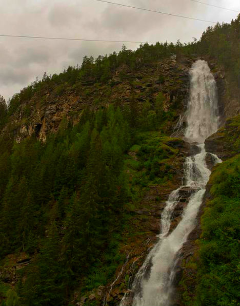
Stuibenfall crashes through the Otztal Alps with a 159-metre free fall that makes it the highest waterfall in Tyrol and the fourth highest in all of Austria. Located near the village of Umhausen, this magnificent cascade plunges over a cliff face that was created by one of the largest landslides in Alpine history. The thunder of the falling water can be heard from kilometres away, and the mist that rises from the base creates rainbows on sunny afternoons. A well-maintained via ferrata climbing route runs alongside the waterfall, offering adventurous visitors a perspective that few other Alpine waterfalls can provide. weather viewed from the bridge below or from the climbing route beside it, Stuibenfall is a powerful natural spectacle that epitomises the raw beauty of the Tyrolean mountains.
\n
Stuibenfall is the highest waterfall in Tyrol, Austria. It is located in the district of Imst, in the Otztal Alps, near the village Umhausen. It is a part of a stream Horlachbach.
\n

\nPhoto licensed under the Creative Commons, created by mindgrow
\n
The Geological Origin: A Landslide-Created Wonder
\n
The story of Stuibenfall begins nearly 10,000 years ago, at the end of the last ice age. As the glaciers of the Otztal Alps retreated, the melting of permafrost destabilised the mountain slopes above the Horlachtal valley. This triggered a colossal landslide of approximately 3 billion cubic metres of rock from the Tauferberg area, one of the largest known landslides in European Alps. The debris dammed the Horlachbach stream, creating a vast natural reservoir behind the rock barrier. Over time, the water pressure built until the stream broke through the dam, carving a dramatic gorge and cascading over the 159-metre cliff face that remains today. The landslide debris is still visible on the valley floor, a testament to the immense geological forces that shaped this landscape. The waterfall continues to erode the soft metamorphic rock of the cliff face, slowly retreating upstream at a rate of a few millimetres per year. Geologists study the site to understand landslide mechanics and post-glacial landscape evolution, making Stuibenfall not only a scenic attraction but also a site of scientific interest.
\n
Hiking Trails, Via Ferrata, and Otzi Dorf
\n
Stuibenfall is one of the most accessible major waterfalls in the Alps, with a well-developed infrastructure for visitors. The village of Umhausen serves as the gateway, offering parking and information. From Umhausen, a marked hiking trail leads to the waterfall along a 450-metre-long secured pathway that runs along the left side of the cascade. This via ferrata, known as the Stuibenfall Klettersteig, is suitable for children aged 10 and older and provides a thrilling but safe way to experience the waterfall up close. The path features steel cables, ladders, and platforms that hug the cliff face, with spray from the waterfall cooling climbers on hot summer days. For those who prefer a less adventurous approach, an easier walking trail leads to a viewing platform at the base of the falls. The complete round trip from Umhausen, including time at the waterfall, takes approximately three hours. Adjacent to the parking area, the Otzi Dorf archaeological park recreates the world of the Iceman, the famous 5,300-year-old mummy discovered in the Otztal Alps in 1991. The park features reconstructed Neolithic dwellings, demonstrations of prehistoric crafts, and exhibitions on Alpine archaeology. Combining a visit to Stuibenfall with Otzi Dorf makes for a full day of natural and cultural exploration, and an additional hour and a half should be budgeted for the archaeological park.
\n
Stuibenfall Waterfall was created about 8000 – 9800 years ago during the glaciers melting. At that time there was a thawing of permafrost which moved the huge masses of rock. The stream Horlachbach was created after a landslide of approximately 3 billion cubic meters of rocks from the Tauferberg area to Horlachtal valley. There was thus created a large water reservoir from which the water broke the way and thus created a Stuibenfall Waterfall.
\n
You still can see the rocks, which originally formed the dam of the lake. Stuibenfall Waterfall is 159 meters high an it is therefore the highest waterfall in Tyrol and the fourth highest in Austria.
\n

\nPhoto licensed under the Creative Commons, created by äquinoktium
\n
Stuibenfall Waterfall is easily accessible from the village Umhausen, where you can also visit the archaeological park of Otzi Dorf (Ice Man Village). The whole trip is also suitable for the children and take approximately 3 hours. If you still want to visit the archaeological park, be prepared for an hour and a half more. Stuibenfall Waterfall is open all year round for free.
\n
Large paid car-park is available at Otzi Dorf. At the Stuibenfall Waterfall there is also climbing arena available. It is 450 m long hedged way, that leads just at the left side of the waterfall. Reportedly it is also suitable for the children from 10 years and older.
\n
View Stuibenfall – the highest waterfall in Tyrol Austria in a larger map
\n
\n
Would you climb the via ferrata beside Austria’s highest Tyrolean waterfall? 🏔
\n
Explore all our Austria travel guides, from Vienna coffeehouses to Alpine peaks.
Explore More
If you enjoyed this article, you might also like:
