The Pindus Mountains run like a jagged spine down the centre of Greece, dividing the mainland into two distinct worlds. On the western side, the Ionian Sea sends moisture-laden winds that create some of the greenest landscapes in the country. On the eastern side, the rain shadow produces the dry, sunbaked terrain that most visitors associate with Greece. This mountain range stretches over 180 kilometres from the Albanian border in the north to the Gulf of Corinth in the south, with dozens of peaks rising above 2,000 metres. The Vikos Gorge, one of the deepest canyons in the world relative to its width, cuts through the limestone heart of the range, dropping 900 metres to the Voidomatis River below.
In the northern part of Greece, at the border with Albania, there is one of the most impressive mountain ranges in the country, the mountains of Pindus (known also as Pindos or Pindhos). Pindus area has only few inhabitants and includes two national parks, the second largest gorge in Europe and the mountain peaks, which are among the highest in Greece.
Pindos massif composed of several separate mountain units (Smolikas, Tymfí, Aigo, Lakmos, Athamanon, Oros Iti, Karava and others). The highest peak is Smolikas reaching an altitude of 2637 meters. It is the second highest mountain in Greece, after Mount Olympus.
Photo licensed under the Creative Commons, created by dementia_inc
The Pindus mountain features two national parks that protect the original and almost intact nature. National Park Vikos-Aoos stretching over an area of 3360 hectares, was founded in 1973 and occupies an area around the Vikos gorge, characterized by its vertical walls, which often reach heights up to 950 meters. The gorge is 12 km long considered one of the greatest natural wonders. There are just several tourists here, so be aware of the fact that during the trip you can meet only a few people. The best time to visit the gorge is the beginning or end of summer, when water flows quiet.
There are two major rivers Aoös and Vikos, powered by a water from melting snow. They flow along the hiking trails, which are inaccessible when the snow is melting. A unique natural phenomenon in the area is 405 m deep Cave of Provatina and the nearby Chasm of Epos, where is an underground lake in a depth of 469 m. This area also includes Astraka plateau and Tymfí massive.
The larger Pindos National Park, which history dates back to 1966 is a home to the bears and wolves, deer, wild boars, chamois, wild cats and also snakes.
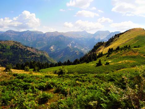
View Pindus Mountain – the spine of Greece and one of the greatest natural wonders in a larger map
In This Article
The Vikos Gorge and Aoos Gorge
The Vikos Gorge, part of the Vikos-Aoos National Park established in 1973, has been recognised by the Guinness World Records as the deepest canyon in the world relative to its width, reaching a depth of 900 metres at a minimum width of just 1,100 metres. The gorge stretches for 20 kilometres from the village of Monodendri to the Voidomatis springs near Konitsa. The hiking trail through the gorge takes approximately six to seven hours and requires a reasonable level of fitness. The path follows the Voidomatis River, crossing it multiple times on wooden bridges, and passes through forest of oak, beech, and black pine. In spring, the gorge floor is carpeted with wildflowers including cyclamen, crocus, and the rare Pindus lily. The Aoos Gorge, further north near the town of Konitsa, is another dramatic limestone canyon that offers a shorter but equally spectacular hike of approximately four hours. The Aoos River, which rises from springs at the head of the gorge, is one of the cleanest rivers in Europe and supports a population of the endangered European otter. Both gorges are accessible from the Zagori villages, a network of 46 traditional stone villages that maintain the architecture of the Ottoman period with slate roofs, stone arch bridges, and cobbled squares.
The Zagori Villages and Stone Bridges
The Zagori villages, known as Zagorochoria, are scattered across the slopes of Mount Tymfi and are connected by a network of paths and traditional stone bridges that date from the 18th and 19th centuries. The most famous bridge is the Plakidas Bridge, a single-arch stone bridge spanning the Voidomatis River near the village of Kipi, with a span of 20 metres and a height of 12 metres. Over 60 stone bridges survive in the region, built by local master masons using techniques passed down through generations. The villages of Papigo, Mikro Papigo, and Monodendri are the most popular bases for exploring the gorge. The stone-built guesthouses in these villages offer traditional accommodation with fireplaces and local cuisine. The region is also known for its production of feta cheese, trahana pasta, and savoury pies filled with wild greens known as horta. The village of Vitsa, perched on a cliff edge above the gorge, has been continuously inhabited since the 10th century. The Zagori region was designated a UNESCO Global Geopark in 2010, recognising its exceptional geological diversity. The best time to visit is between May and October, with July and August being the busiest months.
Mount Tymfi and Mountain Activities
Mount Tymfi, also known as Gamila, is the highest peak in the Pindus range at 2,497 metres. The mountain features the Drakolimni Tymfis, one of two alpine lakes in the Pindus known as Dragon Lakes, formed by glacial activity at an elevation of 2,050 metres. The lake is home to the alpine newt, whose red belly led to the local legend that dragons live in the water. The climb from Mikro Papigo to the summit takes approximately seven hours and requires scrambling over limestone scree. The summit offers views across the entire Pindus range to the Ionian Sea on clear days. The area offers rock climbing routes on the limestone cliffs above the Vikos Gorge, with grades ranging from 4c to 8a for experienced climbers. Rafting and kayaking are popular on the Voidomatis River during spring and early summer when the water levels are highest. Mountain biking trails run through the forest tracks connecting the villages. The nearby town of Ioannina, 50 kilometres south, is the regional capital and offers a lakefront promenade, a 6th-century Byzantine castle, and the Municipal Museum housed in the former mosque of Aslan Pasha. Ioannina is connected to Athens by daily flights and bus services.
Have you ever hiked through a gorge that felt like it was cut from the earth by ancient forces? Where was it?
Explore all our Greece travel guides, from ancient ruins to Aegean beaches.
Explore More
If you enjoyed this article, you might also like:
