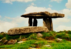
Wind sweeps across the stark limestone pavement of the Burren, carrying the silence of five thousand years to the feet of Poulnabrone Dolmen. This portal tomb stands against the grey Irish sky like a stone doorway to another world, its massive capstone balanced on slender uprights. The ancient builders placed these stones to mark the burial of their dead, and the bones of dozens of people have been found beneath this monument.
Poulnabrone Dolmen, one of the symbols of the Emerald Isle, is probably the most photographed megalithic monuments in Ireland. This “hole of sorrows” is located in the western part of the country, in the Burren, County Clare. It was built during the Neolithic period, approximately in 3200BC.
Poulnabrone Dolmen is a portal tomb, which consists of a huge stone boulder weighing 5 tons, that is supported on two sides by raised stones. The entire formation is a 9 m deep burial chamber whose entrance is turned over to the east. Thus gives the impression that it was used as a sacrificial place in the Celtic period. This mysterious place is most impressive at sunset, when setting sun is lighting surrounding field with clearly purple color.
Archaeological research in 1985 showed that there were buried about 16 to 22 adults and 6 children, including personal belongings of deceased, as it was believed that the deceased needed them on their way to the next world. There were found such as bone pendants, ceramics, quartz crystals, weapons, and stone axes.
As regards natural conditions, vegetation in the Burren area is very poor and there is not enough soil. In the tomb Poulnabrone there is only about 25 cm of the soil and below it there is only a rock. The method of burial is still unclear. The bones of the bodies were separated from each other.
Poulnabrone Dolmen is situated on the R480 road, about 9 km south of the town Ballyvaghan. Admission is free. In the vicinity there are about seventy other tombs.
View Poulnabrone Dolmen – the most photographed megalithic monuments in Ireland in a larger map
The Burren Landscape: Flora and Rock Formations
The Burren, the stark limestone region that surrounds Poulnabrone Dolmen, is one of the most unusual landscapes in Europe. The name comes from the Irish Boireann, meaning a rocky place, and it describes a terrain of grey limestone pavements, known as clints, intersected by deep fissures called grikes. This karst landscape formed over 300 million years ago when the area lay beneath a tropical sea. The shells and skeletons of marine creatures compressed into limestone beds that were later lifted, weathered, and sculpted by glaciers into the extraordinary pavement seen today. The grikes create microclimates where rare plants find refuge from the wind and grazing animals.
The botanical diversity of the Burren is world-famous and seemingly paradoxical. Arctic-alpine plants like the mountain avens and spring gentian grow alongside Mediterranean species such as the dense-flowered orchid, a combination found nowhere else on Earth. This unusual mix exists because the limestone bedrock absorbs heat during the day and releases it at night, moderating the temperature and creating conditions that suit plants from very different climates. In spring and early summer, the grey pavement transforms into a carpet of colour as orchids, bloody cranesbill, and wild thyme bloom in the grikes. The Burren also supports unique butterfly species, including the Burren green hairstreak, which feeds exclusively on plants growing in the limestone crevices. A guided walk with a Burren naturalist, available through the Burren Centre in nearby Kilfenora, reveals the hidden world of this landscape in a way that independent exploration cannot match.
Caherconnell Fort and Aillwee Cave
Less than 2 kilometres south of Poulnabrone Dolmen stands Caherconnell, one of the best-preserved stone ring forts in Ireland. This circular dry-stone fort, built around the 10th century AD, measures 37 metres in diameter with walls up to 3 metres thick. The fort was occupied for over 700 years, and archaeological excavations have uncovered evidence of metalworking, animal husbandry, and trade with continental Europe. Unlike many Irish ring forts that exist only as grass-covered mounds, Caherconnell retains its full height and structure, allowing visitors to walk through the gateway and stand within the enclosure where generations of Gaelic chieftains lived and governed. A visitor centre on site displays the excavation finds, including pottery fragments, iron tools, and animal bones, and offers a short film on the history of the fort. Sheep demonstrations showing the traditional Burren grazing practices take place during summer afternoons.
Aillwee Cave, located 5 kilometres northwest of Poulnabrone, offers a completely different experience of the Burren’s geology. This 1.5-kilometre limestone cave system was formed by rainwater dissolving the bedrock over millions of years. A guided tour takes you 50 metres underground along a paved walkway past stalactites, stalagmites, and subterranean waterfalls. The cave maintains a constant temperature of 10 degrees Celsius year-round, so bring a jacket regardless of the weather above. The highlight is the Bridge of Rock, a natural limestone arch that spans a deep chasm within the cave. Above ground, the Birds of Prey Centre at the same site houses eagles, hawks, falcons, and owls in large aviaries, with daily flying demonstrations. The combination of Poulnabrone Dolmen, Caherconnell Fort, and Aillwee Cave makes for a full day of Neolithic, medieval, and geological exploration that captures the essence of the Burren’s extraordinary heritage.
Have you felt the ancient silence of the Burren? 🪨
Explore all our Ireland travel guides, from Dublin pubs to the Wild Atlantic Way.
Explore More
If you enjoyed this article, you might also like:
