Kmeťov vodopád (Kmeť’s Waterfall) is the highest waterfall in Slovakia, a spectacular 80-metre cascade in the remote Kôprova Valley (Kôprová dolina) of the High Tatras, plunging down a near-vertical granite wall in one of the Tatra National Park’s most pristine and less-visited valleys. Named after the Slovak botanist and ethnographer Andrej Kmeť, this waterfall is the centrepiece of one of the High Tatras’ most rewarding but demanding day hikes, a full-day expedition through unspoilt mountain wilderness that rewards with a genuinely wild waterfall experience far from the more crowded Tatra trails.
In This Article
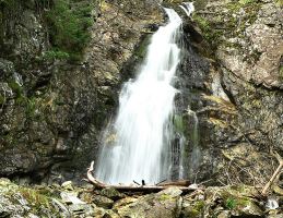
Geography and Geology of the Waterfall
Kmeťov waterfall measures approximately 80 metres in height, making it the tallest waterfall in the Slovak High Tatras. It descends in two distinct steps through a crack in the rock threshold, creating a dramatic split cascade that is most impressive during the spring snowmelt. The waterfall is fed by the Nefcerský stream, which flows from an altitude of 1,245 metres and is about 1.5 metres wide at the cascade point. The surrounding geology consists of granite and metamorphic rocks typical of the core zone of the High Tatras, shaped by glacial activity during the Pleistocene era. The two-step structure of the waterfall is unusual and results from differential erosion of the underlying rock layers, with harder granite sections forming the upper step while softer metamorphic rock has eroded more quickly below.
The waterfall is located in the Kôprova Valley, a 12-kilometre-long valley with numerous side valleys that sits between the Western and High Tatras, beneath the western slopes of the dominant peak Kriváň, one of Slovakia’s national symbols. The valley and the Kriváň area preserve traces of an old mining tradition, particularly associated with historical gold mining activities. This mining heritage adds a layer of historical interest to what is already a spectacular natural destination. Small remnants of mining tunnels and spoil heaps can still be found along some of the side trails, serving as quiet reminders of the human presence that once thrived in these remote mountain valleys. The valley’s name, Kôprova, derives from the Slovak word for dill, reflecting the abundance of wild herbs that grow in its meadows.
The Hike Through Kôprova Valley
The trail to Kmeťov waterfall begins at the Kôprova Valley junction on the Cesta Slobody (Freedom Road), which connects Štrbské Pleso and Podbanské. The hike covers approximately 12 kilometres each way and takes three to four hours depending on fitness level and trail conditions. The path follows the Kôprovský stream through a forested lower valley before emerging into the open alpine zone where the waterfall becomes visible. The trail is well-marked but remote, with no mountain huts or facilities beyond the valley entrance, so hikers must carry sufficient food, water, and safety equipment. The lower section of the trail passes through mixed beech and spruce forest, where the canopy provides welcome shade on hot summer days and the sound of the stream provides constant company.
Along the way, the trail passes several smaller waterfalls and crystalline mountain streams. In the upper sections, hikers can see the distinctive Tatra chamois and marmots if they are lucky. The valley also offers opportunities to ascend to mountain saddles and to the Kôprovský peak for those seeking an even more challenging route. The best time for the hike is from late May to October, though the trail typically opens fully only from mid-June after the spring closure period for wildlife protection. Spring offers the greatest water volume as snowmelt feeds the waterfall, creating a thunderous roar that can be heard from a considerable distance. Autumn brings stunning colours to the valley, with the blueberry bushes turning crimson and the larch needles glowing gold against the dark granite slopes.
Planning Your Visit to the High Tatras
Reaching the Kôprova Valley trailhead requires a car journey of approximately four hours from Bratislava. The nearest major resort is Štrbské Pleso, which offers accommodation, restaurants, and access to other Tatra trails including the popular hike to the Symbolic Cemetery, a memorial to climbers who have lost their lives in the Tatras. Hikers should be prepared for moderate to demanding difficulty, as the valley trail is long and requires good physical fitness. Weather in the High Tatras can change rapidly, with clear mornings giving way to afternoon thunderstorms with little warning, so layered clothing, rain gear, and proper hiking boots are essential. All visitors to Tatra National Park must stay on marked trails to protect the fragile alpine environment. Mountain rescue services are available through the Horská záchranná služba, and it is advisable to register your hiking plan at the nearest hotel or mountain hut before setting out on longer routes. A headlamp, first aid kit, and an emergency blanket should be part of every hiker’s pack, along with at least two litres of water per person for the full-day hike to the waterfall.
View Kmeťov waterfall in Kôprova valley – the highest waterfall in Slovakia in a larger map
Have you hiked to Kmeťov Waterfall or discovered the quieter valleys of the High Tatras? Share your Slovak waterfall discoveries in the comments! 🌊
Explore all our Slovakia travel guides, from the High Tatras to Bratislava charm.
Explore More
If you enjoyed this article, you might also like:
